Urban Curiosity
Jul. 6th, 2007 04:22 pmSo today I decided to go to Veteran's Memorial Park in Sylmar, which as I mentioned yesterday was the site of the VA hospital destroyed in the 1971 Sylmar earthquake.
The first thing I need to find is a site map of the hospital to overlay on the park map.
I noticed two major buildings. One was a community room that screamed late 70's design, and the other was used by LA Mission College. That building was very typical late 40's / early 50's design.
The first picture is of the hospital after Feb. 9th, 1971
http://pubs.usgs.gov/fs/2005/3052/images/fig1.jpg
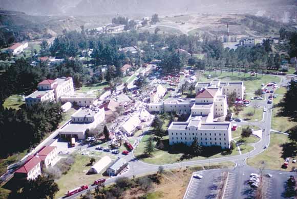
If I have placement of the street design in that park right, (and it doesn't look changed at all from the VA Hospital days), that building would be towards the upper right hand corner.
Now for the people on my friends list that go to SCA events in the Barony ofAngels Altavia, that parking lot in the lower right hand corner may look familar. Here's a second picture, which brings elevational changes out more.
http://libraryphoto.cr.usgs.gov/htmllib/batch85/batch85j/batch85z/kac00057.jpg
So if I'm looking at these pictures right, that parking lot is the one most people park at for events. Which would make the tourney field next to and under the larger building in the foreground.
Anyone want to comment on it? Or tell me where I can find a site map to check for sure?? :-)
The first thing I need to find is a site map of the hospital to overlay on the park map.
I noticed two major buildings. One was a community room that screamed late 70's design, and the other was used by LA Mission College. That building was very typical late 40's / early 50's design.
The first picture is of the hospital after Feb. 9th, 1971
http://pubs.usgs.gov/fs/2005/3052/images/fig1.jpg
If I have placement of the street design in that park right, (and it doesn't look changed at all from the VA Hospital days), that building would be towards the upper right hand corner.
Now for the people on my friends list that go to SCA events in the Barony of
http://libraryphoto.cr.usgs.gov/htmllib/batch85/batch85j/batch85z/kac00057.jpg
So if I'm looking at these pictures right, that parking lot is the one most people park at for events. Which would make the tourney field next to and under the larger building in the foreground.
Anyone want to comment on it? Or tell me where I can find a site map to check for sure?? :-)